Antoine Hardy (1838–1907): The Federal Homestead Patent and the St. Landry Prairie Line
Real family history does not hide behind blacked-out screenshots. It puts the document on the table, with the numbers showing, where anybody can check it.
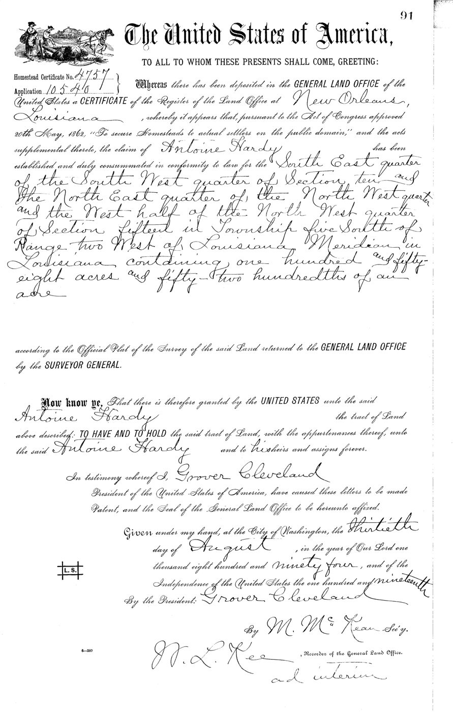
This is the original United States Homestead Patent, Certificate Number 4757, Application 10540, issued August 30, 1894, and signed by President Grover Cleveland. It granted 158.52 acres of prairie land in Township 5 South, Range 2 West, land that sat in St. Landry Parish then and sits in Evangeline Parish now, in the Mamou country, to one man: Antoine Hardy, my third great-grandfather.
Antoine was born in October 1838 at Welsh, on the prairie of Southwest Louisiana, in a country that was already old with his people's names. The line he carried runs back through the Latiolais and Nezat families of the old Attakapas district. He married Marianne Allain, and their daughter, Azama Marie Hardy, carried the line down to my great-grandfather Alsay LeDay, to my grandmother Lena LeDay, to my father, and to me.
After the Civil War, Antoine did what the Homestead Act asked of a man. He settled the land, worked it, and proved up his claim. The Louisiana State Land Office tract books entered his certificate on June 21, 1888. Six years later the United States issued the patent itself, out of the New Orleans land office, in his name, and to his heirs and assigns forever. The same certificate number, the same sections of land, in two separate record systems, federal and state, agreeing with each other. That is what documentation looks like.
He was still on that land in 1900, in Upper Mamou, when the census taker came through. He died about 1907, on the ground the United States had granted him.
Every number in this piece is open to the public. The patent sits at the Bureau of Land Management's General Land Office under Accession STA-LA0410__.091. The tract book pages are in the Louisiana State Land Office's historical records. Anybody can pull them tonight, for free, and read the same words I read.
No markers. No blacked-out names. Just the document, and the line it proves.
Sources
U.S. Bureau of Land Management, General Land Office — Homestead Certificate No. 4757, Application 10540, Accession STA-LA0410__.091; patented August 30, 1894; Township 5 South, Range 2 West, Louisiana Meridian, Sections 10 and 15; 158.52 acres.
Louisiana State Land Office, Historical Records — U.S. Tract Book, Opelousas District, Vol. 14A, p. 146 (Section 10) and p. 149 (Section 15); entry dated June 21, 1888, Certificate 10540.
1900 U.S. Census — Upper Mamou, St. Landry Parish, Louisiana (residence of Antoine Hardy).
Researched from the original records. Prepared with the help of AI — the documents, the citations, and the history are real.
The documented work is shared as it surfaces on Facebook.
© 2026 Clayton Antwan Williams. All rights reserved.